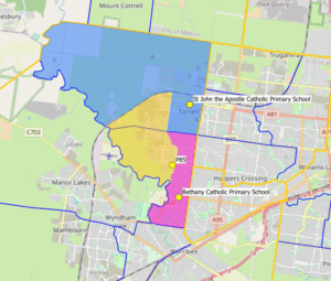
The catchment area of St John the Apostle is defined by the following boundaries:
- North of Sayers Rd and the Railway Line
- West of Tarneit Rd
- South of Boundary Rd
- East of the Werribee River and Davis Rd
Please refer to the following map for a visual representation of the catchment area.
- Blue Section – St John the Apostle Catchment
- Yellow Section – St Martha of Bethany Catchment Area (Opening 2027)
- Pink Sectiom – Bethany Catholic Primary School